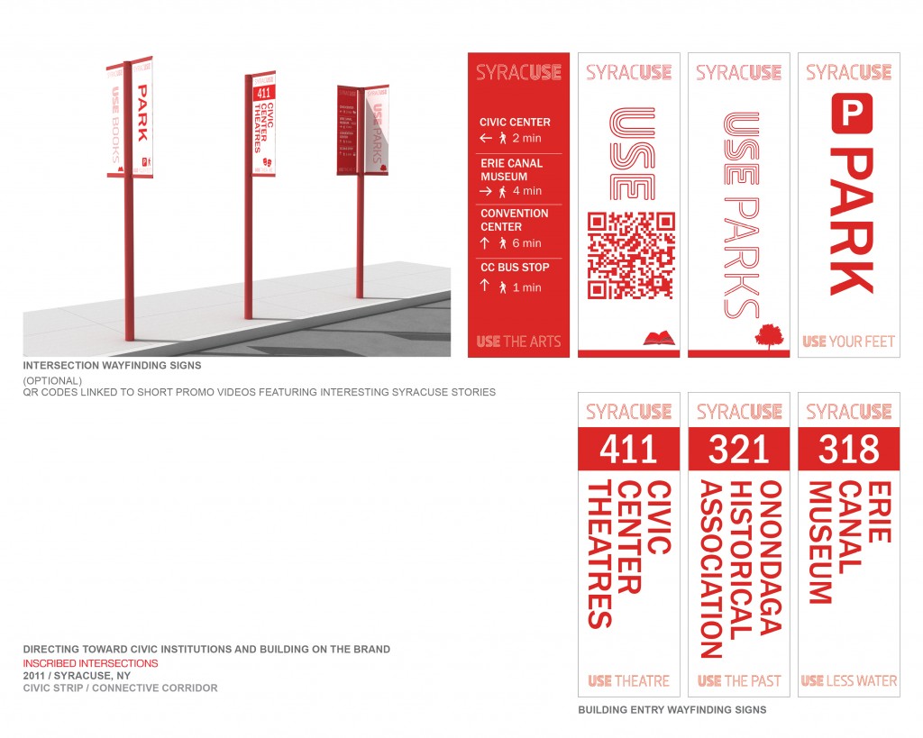
Brand new signs to help people navigate downtown Syracuse more easily will highlight the second stage of the Connective Corridor project.
“We’re going to be putting in place basically a downtown signage system that tells people how to get from the Civic Center to Armory Square. How to get there and how long it takes to walk,” said Linda Dickerson Hartsock, the director of Syracuse University Community Engagement and Economic Development.
Forty signs will dot the “Civic Strip” portion of the Connective Corridor. The Civic Strip runs along Montgomery Street and State Street between Water Street and Adams Street, and along Jefferson Street from State Street to Franklin Street. The signs will be at every intersection along these streets.
The Connective Corridor is a $42.5 million street improvement and transportation system connecting University Hill and downtown Syracuse, funded through various state and federal grants. The Civic Strip portion is funded by a $1.9 million federal stimulus grant awarded to Onondaga County, with matching funds from New York State to SU, Hartsock said. It connects the OnCenter complex, civic institutions and cultural organizations with Armory Square.
In addition to the signs, the Civic Strip will have more green space, plants and interactive entries to such major tourism venues as the Erie Canal Museum, Everson Museum and Onondaga Historical Association.
Greg Tripoli, executive director of the Onondaga Historical Association, suggests the signs will engage pedestrians and make downtown Syracuse more walkable. Connecting the arts and cultural venues to people will greatly increase the city’s tourism and overall attractiveness, he said.
“It’s one thing to get people on the street, but they also need to know where they’re going,” Tripoli said. The signs point people in the direction they want to go, he added. “The particular sign they are using not only shows where and amenity is, it also tells you how long it’ll take to get there.”
David Holder, president of the Syracuse Convention and Visitors Bureau, cites visitor surveys that rate Syracuse low in walkability. “We just do not make it easy for our visitors to get around and understand different things to see and do in this town,” Holder said. The new signs will change that, he said.
“That look and that appeal is just going to elevate people’s understanding,” said Holder, “of how diverse and how widespread the different things to see and do in Syracuse are.”
The cost of the signs themselves will depend on the details of the signs and what materials will be used, said Joseph Sisko, assistant director of UPSTATE, a design group in the SU School of Architecture. UPSTATE is designing the signs, using aluminum and the red color scheme of the Connective Corridor. Sisko estimates each sign will cost $2,500 with installation. The total cost of all the signs, he said, will be between $25,000-$30,000.
“We’ll essentially have two signs at each intersection,” Sisko said. “One face on the side of the sign would have an institution, an arrow and then sort of a graphic of a pedestrian and the walk time from that intersection to that institution.”
Through the signs, SU’s Harstock predicts, Syracuse will become a much more walkable city. “People like to explore cities by walking,” she said. “We all think this way-finding system, as street signs but also tied to bus signage and bus routes, will really make it easier for folks.”
(Tyler Greenawalt is a junior with dual majors in newspaper and online journalism and political science.)
-30-


